Monday, February 24, 2014

Road Trip Roundup (including Gunnison)

I realized that, in my effort to bring the blog up-to-date, I skipped two fabulous day trips we took in the car (from La Cueva, NM), so jumping in the time machine, back we go…

… first, all the way back to the first weekend in September, for Santa Fe's 89th Annual "Burning of Zozobra," a highlight of the Fiestas de Santa Fe (which started in 1712!).  Zozobra ("Old Man Gloom") is a giant marionette invented by a local artist (Will Shuster) back in 1924.  Meet Zozobra:

Santa Feans bring their worries (and sometimes even legal matters!) in writing to put in the "gloom box" that burns at Zozobra's feet during his fiery demise: every year, Zozobra (sporting a different hair color) burns to relieve festival participants of their troubles. 


As he burns, he waves and points at the audience, wags his head back and forth, and opens and closes his mouth in simulated agony, as shrieks, moans and groans are pumped through loudspeakers.  It is quite an awesome spectacle (and probably pretty scary to the kiddies).
Isn't he just fabulous!


And, when Zozobra is finally reduced to a smoldering heap, 
his annihilation is celebrated with a spectacular fireworks display!


Yes, indeed: Thank You, Santa Fe!

************************************************************************************************************
The following weekend, we drove to Bandelier National Monument.  Bandelier is home to a spectacular set of Pueblo Indian ruins, built between 1150 and 1550 AD.


[Aside:  I just hate the erroneous term "Indian", and the fact that the name has stuck for, oh, the last 500+ years.  It also speaks to the arrogance of Christopher Columbus: I mean, if you had a bad map and ended up in, say, Nova Scotia, instead of Maine, would you persist in calling the local people "Mainers?!"  Sheesh.]

Anyway, the Pueblos settled in Bandelier because they were able to dig elaborate cave homes into the (relatively) soft volcanic ash-based rock called tuff, ejected 1.14 million years ago by the Valles Caldera Volcano eruption.  They also used the underlying, harder shales and sandstones as building materials, for additional housing and ceremonial round-houses called kivas.


Houses were built with shared walls: is this the original apartment complex?


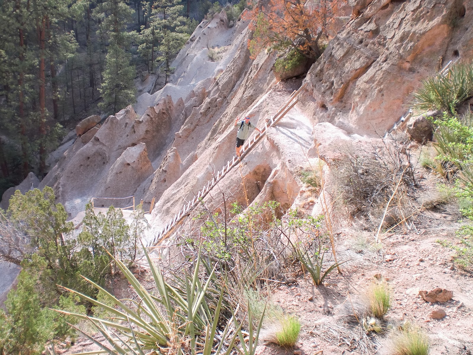
Perhaps our favorite aspect of the park was the danger/solo factor: 
we only saw two other people the whole time we walked around… 
and no one scolded us to keep both hands on the ladder:


The view from inside the ruins was pretty fabulous too:


We also encountered some impressive flood debris.  The region had been hit by a major drought, followed by the Las Conchas forest fire in 2011, and had not yet recovered.  When a fire burns and kills trees, they are no longer around to absorb water: ironically, then, a region desperately in need of soil moisture cannot actually trap rainfall after the fire has wiped out its trees.  So, you end up with flash flooding every time there is a serious rain… and the water moves away from where it is desperately needed.  Awful.

One last dangerous bit of hiking (Nate insisted...) and that wrapped up our visit to Bandelier!


************************************************************************************************************

At last, let's flash forward to the actual day trip I promised I'd write about in this post: on February 8th, we drove from South Fork to Gunnison, CO.  We'd been feeling like we'd fallen into a bit of a routine/rut, so we thought a little day trip would perk us up a bit.  Why Gunnison?  Well, we'd been told by several people that the drive (in particular, from Creede to Lake City) was one of the most spectacular in this whole part of the state… and we were absolutely starved for snow.  After hearing that we'd be regularly snowed-in for the entire winter, we'd been consistently let-down by the warm, dry conditions.  Boo, Climate Change.  Boo.

So, here's our route (not a fan of the new Google maps, which wouldn't let me customize this for you): we drove up to Gunnison on 149 (in gray at left) and back on 114-to-285-to-160 (in blue).


It really was a gorgeous drive.  Here's a bit of the scenery we thought we should share: 

After you pass Creede, you come to the headwaters of the Rio Grande:

As you can see, we definitely got the snow we were craving!
And then arrived in Lake City, CO (cute, tiny town):
Found a fabulous house with a cave below it (how cool is that?):
Saw some gorgeous mountains
(assuming these are what they call 14-ers: minimum 14,000 feet at their peaks):

And then, finally made it to Gunnison, where big flakes of snow were falling and coating the whole town in a blanket of white.  We hit a couple of thrift stores and-- miraculous!-- finally found Nate a $5 pair of cross-country ski boots.  Afterward, we ate a late lunch (or was it an early dinner?) at a great little pub that makes homemade giant, gooey cookies.  

Yeah, we had to have one.  ;)

We took a faster route back: less scenic, but we did most of the drive in the dark anyway.  It had been a very long day of driving, but we're glad we saw just a bit more of SW Colorado before we leave for Oregon… which, by the way, is happening at the end of March, not the end of April (thanks to our gracious landlord)!

Up Next: Our Favorite Furry Things


Monday, February 10, 2014

For the Love of Cob... We *Finally* Figure Out Our Next Move!

So... as you all know, our "big adventure" started last summer with a big misadventure, courtesy of the Solar Ark.  Instead of spending somewhere between one and six months there, learning everything from solar energy to water catchment to natural building and living nearly cost-free, we spent a week there cleaning and working in the garden and realizing we were not going to get any sort of education in return... and then fled!

As it turns out, fleeing is very costly.  :(

After six months of loosely stringing together one backup plan after another, spending time, money, and effort every step of the way (see all previous posts, for reference), we ultimately ended up renting a Colorado cabin for the winter, to give ourselves six months of geographical stability and time to figure out the answer to the question that has plagued humans since the dawn of time: "What next?"

Well, at last, gentle readers, we have the answer!

We pack ourselves and the cats back into Baba G, some time in April, and drive to Bandon, Oregon!

View Larger Map

As you have certainly noticed, we will be backtracking east quite a bit {*sigh*} at the start of the trip... because there is no way we can get Baba G up and over Wolf Creek Pass, without risking a major catastrophe: think brake fires and blown transmissions.  Besides, we would like to spend a little time around Denver and Boulder before we leave Colorado, and we are pretty sure we'll enjoy the scenery in Wyoming and Idaho (green) more than Utah and Nevada (brown).

So, why Bandon?  

Well, we have spent many many many hours googling, considering options as disparate as:

(1) Summer jobs at Yellowstone resorts: Hmm... handling screaming kids and toxic cleaning products for minimum wage?  Pass.

(2) RV camp hosts, working 20 hours per work each in exchange for full hookups.  Yeah, so let's do the math here: 160 man-hours per month for electricity, water, and sewer... hmm... that might work out to $1 an hour.  Pass.

(3) Natural building work exchanges (though we are still pretty gun-shy since the Solar Ark).  After taking some time to really think through our goals with this whole crazy move-across-the-country-start-a-sustainable-building-school thing, we realized our biggest frustration with the journey so far has been that we have not done any hands-on natural building yet.  Enter: Bandon.

Following a link from a page from a link from a page from a link... {well, you get the idea}... I found an advertisement for an RV site for rent in Bandon, Oregon.  Cheap!  But why would we rent a site, rather than try for a free one somewhere?

Because the site is at a renovated 1930s motel facility which is hosting a 9-day "cob intensive" workshop in July, has six cob cabins that need finishing, and they specifically advertised the RV site for people who want to do some hands-on... natural building!  In response to my emailed inquiry about the site and the natural building, we received an emailed reply from Tammy, saying we should call her at home to discuss particulars.

[As an aside, cob was the first natural building material I became interested in: cob is soil, straw, and water, pounded together and formed into a large loaf.  It is an ancient building technique that is inexpensive, simple, and structurally sound: it is essentially like hand-sculpting a house!  For more about cob, check out this link.  And check out some really beautiful cob homes here.]

We called that same night, and talked with Tammy for about an hour (maybe more...), happily discovering that (1) the kitties were welcome, (2) our arrival date of April-May was acceptable (amazing, since the ad only mentioned a site available February 1st!), and (3) Tammy is a wealth of knowledge about natural building methods, and is also the hub for the entire natural building community in the Pacific Northwest... and beyond.

We have finally found our way into natural building!

Our journey has purpose, once again!


Up Next: Road Trip to Gunnison, Colorado


Durango: The Town That Gets "Snowdown"

Way back in November, after we'd just gotten Baba G and ourselves settled for winter (which we're still waiting for...), we took a road trip westward, past Pagosa Springs, to the town of Durango, Colorado.

View Larger Map

Durango is a pretty big mountain/skiing/college town with a cute, walkable downtown, several microbreweries (we went to Ska Brewing Company on this trip, and even did the brewery tour: very interesting and we got cans of their Modus Hoperandi before the lids were screwed on!):


Most importantly to us, Durango has an eye clinic with several ophthalmologists on staff!

Since Nate had injured his right eye back on October 1st,  we knew we needed to find a new eye doc and get him in for a check-up around 100 days after his injury (early- to mid-January), because there is a potential complication called "100 Day Glaucoma" that can occur after closed-globe injuries.  If it happens, internal eye pressure rises (that's glaucoma)-- it can happen very quickly-- and can put so much pressure on the retina, it can damage the photoreceptors back there, causing blindness!  =:-O

So, after our first reconnaissance trip to Durango, Nate called around to various eye clinics and made an appoinment for January 15th.

The good news: his vision is 20/20 in the injured eye!  Good thing, since he's been doing a lot of the driving lately!  =:-O
   Me without glasses    Nate without glasses

The bad news: the doc is pessimistic about his pupil completely returning to normal size, since it has not changed much in the 100 days since his injury.  (I, however, have been noticing that his pupil is smaller, from time to time: it seems to us that the iris is functioning inconsistently, which we are going to take as evidence there is still healing going on.) 
Fingers crossed, everyone!

The other good news: the visit was covered by our new Medicaid policy!  Yay, Obamacare!  (For us, it is a total lifesaver.)

The other bad news: we needed to make at least two more followup appointments, so we'd have to make the long road trip (103 miles and two hours, each way) to Durango a couple/few more times.

Oh, well, we thought.  We'll just have to check out the other breweries in town.  And then recheck our work.  Twist our arms.  ;)

Back we went on January 31st: the doc said Nate could start tapering down his corticosteroid eye drops and stop using his eye-pressure-reducing drops over the next couple of weeks-- progress!

As it turns out, the 31st was also the kickoff for an annual Durango celebration called "Snowdown."  So, after Nate's afternoon appointment, we went to Ska (our favorite of the four breweries we'd sampled) for pizza and a couple of beers.


Then, we drove downtown for the Snowdown parade, which many of the locals apparently think is too "X-rated" to be a family event.  We had to laugh a bit when we read this in the paper: what on Earth would these folks think of Fantasy Fest?!  


Avert your eyes, Nate!  Here come fully-clothed paraders!

Snowdown is downright tame, though we were impressed at the crazy flamethrowing (from hot air balloon baskets on floats):


The parade was impressive, both in terms of its length and the time and effort put into the floats and costumes.  


And, it was the first day anyone SW Colorado (including Durango and South Fork) had actually gotten accumulations of snow... since early December!  The mood of the crowd was definitely celebratory.


Once the parade was over, we had to hop right in the car and head back home: the two-hour drive in the dark is treacherous enough, with mule deer and elk potentially waiting to jump out in front of you all along the way, but even more so with falling and blowing snow and icy roads added to the mix.

Since Nate had driven us there, it was my turn to get us home.  The roads weren't too bad, and we were making pretty good time, so we decided to stop at the other brewery in Pagosa Springs (aptly named the "Pagosa Brewing Company" to see if maybe we should add them to the Tuesday rotation.  Nah.  Very different atmosphere than Riff Raff: more family-style restaurant, rather than hip brewpub.  [We were already pretty wiped out, and totally spaced on taking pictures.]

We were thinking the decision to stop and check out the brewery had been a pretty good one, until we got to Wolf Creek Pass: the plows hadn't scraped down to bare road like they usually did.  Instead, there were about 1-2 inches of hard-packed snow under the tires, and it was pretty slippery.  I tried to keep our speed right around 30-35mph, concerned that if we fell below that, we might not have enough forward momentum to keep climbing... and if we went over that, we might slip-and-slide right out of control.  Not my favorite kind of driving...   but at least we made it home in one piece!  :{

Up Next: For the Love of Cob... We Finally Figure Out Our Next Move!


Over the Mountain, and Through the Woods... to Pagosa Springs We Go...

Tuesdays are locals days at the The Springs Resort & Spa, so, most Tuesdays, we head over Wolf Creek Pass, through the cool tunnels...


 Over the top of the pass (Nate wants me to tell you this is also the Continental Divide)...

And into the town of Pagosa Springs (on the map in the last post, for you geography buffs).

Once at the springs, we get in for $8 each (!!!), instead of the walk-up price of $24.50 each-- quite the discount.  The picture below shows just a little part of their facility: the building at top left is the main entrance and shower building; the pond you see is warm and has small koi swimming around in it; the walkway is actually under the water by a few inches and leads to an isolated hot pool to the right of the frame; extremely hot water is bubbling out of the top of the volcano-looking structure (made of mineral deposits that have built up over time); and there are a couple of very hot pools (108-109 degrees F!) to the left of the "volcano."

Of course, it was Laurie 2 Dogs who told us about this, too!  Truly, I think if we hadn't met her, we'd just be sitting in the cabin, home alone with the cats, twiddling our thumbs.  ;)

The springs are bigger and nicer than any we've been to before!  For reference, here's a map of the pools (the pic above was shot across Golden Pond toward the main Bath House:


The pools range from 87 degrees (Blue Lagoon swimming pools: mostly to keep the kids occupied while parents soak, from what we've seen) to 116 degrees (Lobster Pot soaking pool).

If no one had developed the hot springs, they would still look like they did in 1874:
File:PAGOSA HOT SPRINGS, COLORADO - NARA - 524217.jpg 

The Ute Tribe, who were here before white settlers came through (and we all know how that went...), gave the town its name: in Ute, "pah-gosah" means healing waters.  Happily, there is still a large Ute population living in this region today, though we never see them soaking at the springs.  :(


Perhaps the coolest thing (no pun intended... hehe) is that the San Juan River runs right next to the springs (Nate is looking at it, above), and you can actually get in the river: sadly, you have to slowly, painfully immerse yourself into the just-above-freezing water, as there is no deep spot to jump in).  Nate has gotten in-- fully-- twice!  I have gotten in-- up to my waist-- twice.  Man, I have turned into such a wimp when it comes to cold water!  To think, a Florida guy putting an Ohio girl to shame like this.  :(

We usually go in the early afternoon, soak for a couple of hours, moving from pool to pool to vary the temperatures (and sometimes, to avoid having to share a pool with anyone else).  And then-- the best!-- we dry off, and head over to Riff Raff Brewing Company for their happy hour (3-6pm). 
http://s3-media4.ak.yelpcdn.com/bphoto/NLpoHS6bWmyJuhizbUuqXg/l.jpg

We enjoy really great beer-- two each-- (though my Russian Imperial Stout: "Weapon of Self-Destruction" was only a winter seasonal, that's been taken off the menu... boo hoo!  Nate's favorite "HopGoblin" IPA is available year-round.) and fabulous nachos, and we're always out of there for about $20, including tip!

Once, on New Year's Eve, we went to Riff Raff first, and then to the hot springs, to soak in the dark.  While the evening ambiance could have been lovely, Texas and New Mexico (we're pretty sure it was the entire state population of each) were already soaking, when we arrived.  Listening to twangy, overly-confident, dufus teenagers hit on each other kinda, well, ruins the hot spring vibe for us.

After a less-than-relaxing soak, we dried off, walked across the bridge taking some pictures of all the beautiful holiday lights,

 Visitor Center, next to The Springs

Bridge across the San Juan River, with hot spring steam visible at left.

... then we headed up and across the pass again, in time to watch the New York Times Square festivities on TV, which happens at 10pm here (Mountain Standard Time is really great sometmes).  Too bad Ryan Seacrest just ruins it for us every time: we miss Dick Clark!  :(  Fortunately, someone put together a montage of every New Years Eve hosted by Dick Clark, starting back in the 70s, so we watched that afterward to sort of cleanse our palate of Seacrest.  ;)

And thus ended 2013 for us: what a crazy year it had been!  We were very excited to turn the page to 2014 and wish each other a Happy New Year.


Up Next: Durango: The Town That Gets "Snowdown"

Sunday, February 9, 2014

Fishing for comments! What do you think of my (possibly final) logo for my company?


As most (all?) of you know, I have been slowly, but surely working toward opening a tiny company to sell my homemade, eco-friendly, healthy skin care products.  The initial offerings are going to include sunblock, moisturizer, lip balm, and sugar and salt scrubs.

We finally have a name (Green Envie) and a website that's actually a dot-com, and not some sketchy dot-net or dot-info.  I have been working on the logo for waaaayyyy too long now… so getting some new eyes on this would be absolutely invaluable.

Before I finalize the logo and put it on my website (greenenvie.com), business cards, and product labels… I would love some input from you all.  You can email me or add comments on this post.  Some of my concerns:

Can you read it?

What do you think of the colors?

Does it bother you that the bottom of the "G" doesn't touch the outline of the logo, as all the other letters do?

Suggestions for changes/edits?

Thanks in advance and I'll be back to blogging about Colorado stuff in the next post (later today).  :)

--Sherri

Holidays in the Valley

The San Luis Valley, that is.  ;)

Just about a week after our arrival here in South Fork, we got a nice big snowstorm, which immediately put us in a holiday mood.  

Snow did not put the cats (that's Tigger) in a holiday mood.  Poor Florida kitties!

Feeling a bit cabin-feverish, we jumped in the car on November 11th, to take a ride up to Creede, a nearby historic silver mining town that recently regained some notoriety as one of the main shooting locations for the (fairly ridiculous) Lone Ranger movie, starring Johnny Depp. The 45-minute drive from South Fork to Creede is pretty gorgeous:


And there is a resident herd of Bighorn Sheep whose territory is about midway along the drive: you don't always see them, but we spotted them on our very first drive up!


Creede is a really cute little mountain town (whose downtown we took no pics of yet, somehow... sheesh), but apparently, all winter, it is pretty much a ghost town.  Fortunately, we found one of (maybe?) three open restaurants-- Kip's Grill-- and had some fabulous fish tacos with salsa made in-house.  Muy delicioso!

We also got to see the hockey ponds (two!) and the fabulous fire station-- built into an old mine shaft in the mountain:


We even found a house that reminded us of the Keys, right down to the (metal) palm tree!

 
After our tour of Creede, we found ourselves wanting to do something else… well, more social.  Since we'd arrived here just before the first big snow, everyone was already hunkered down for the winter, or they were just plain gone.   Most of the people who live in South Fork are only seasonal residents: the population dwindles from ~5000 in summer to ~500 in winter.  At first, we were inclined to be bummed out by that news: who were we going to find to hang out with?  But then, we learned that most of those 4500 are from Texas.  Consider us no longer bummed.

Anyway, back at the ranch (hehe), we found an announcement asking for volunteers to help serve South Fork's (free!) Thanksgiving Dinner.  After a little discussion with Nate, we decided it would be a really nice thing to do on Thanksgiving, given that we had nowhere to be this year.  :(  I called and signed us up.

We arrived to a flurry of activity.  And I say flurry because it was, well, disorganized and patchy.  There was a veteran crew of volunteers, who'd been doing this dinner for years, who functioned together like a well-oiled machine.  Then, there was us, and all the folks  like us, who looked slightly disoriented and guiltily hung out in a line around the outside perimeter of the serving and seating areas.  We couldn't quite grasp this at first, but the organizers somehow had too many volunteers on hand!  When does that ever happen?

Though we only felt minimally useful and ended up leaving after the first "shift," it was a really good thing we went, because when we were instructed to grab our dinners, we sat down directly across the table from a terrific woman named Laurie "2 Dogs," who has lived in South Fork for 16-17 years and knows everyone.  Right away, she started introducing us to people, and said we should come to an event called the "Gala" in the next town over (Del Norte, pronounced as if it rhymes with "swell fort") on December 7th, so we could meet that whole crowd.  She said the core crowd of Del Norte people were here year-round and they had a lot of social events that she attended, because South Fork had… well, nada.

I thought it was high time I showed y'all a map of (most of) the San Luis Valley, to give you some frame of reference.  

If you start at the lower left corner of the map, you'll see Pagosa Springs, which is not in the valley but does have an incredible hot spring (and microbrewery) that we visit on locals days, most Tuesdays.  Sort of our weekly date.  ;)  More on that in the next post.

If you follow 160 through that big green, jagged stuff, congratulations: you just crossed Wolf Creek Pass… the easy way!  Right at the spot where 160 turns due east, that little unmarked kink is South Fork (due south of the "Rio Grande National Forest" label).  Go figure, we'd find a kinky spot to live.  Hehe.

If you continue eastward on 160, the next unmarked kink (where the fork happens) is Del Norte.  Then, keep going east and you'll see Monte Vista (actually labeled) and then Alamosa, even farther east.  Alamosa is the "big city" (yeah, not really…) where we have to go for any big shopping.


View Larger Map

So, now you know where we are and all the places we drove around in December, seeking holiday cheer (and Christmas lights!).  

Anyway, not much happened between Thanksgiving and the first weekend in December, except more snow.  Poor kitties.  
"I thought there was something I read once about "Puss in Boots": where are my boots?

 But Nate was in heaven.  Eating literal snowcones-- with maple syrup!


And then, we got two weekends in a row of Christmas parades, tree lighting ceremonies, decoration contests, and even fireworks!  The first weekend, we went to Del Norte's Christmas parade (one town east of us), even though the forecast was calling for single digit temperatures.  A bunch of locals watched the parade from their cars!


Brrrrr!


 Luminarias!  [And, yes, Virginia, that is police tape...]

Sorry for the blurry image, but I think my eyes were frozen when I took this.  =:-O

The next weekend, we amped up our holiday spirit even more by driving up into the nearby National Forest with an axe, a borrowed saw (thanks, 2 Dogs!), an $8 Christmas tree permit, and many many layers of clothing.  Our mission: cut down our own Christmas tree, for the first time ever!  Of course, I started feeling bad for the soon-to-be victim, as soon as we parked the car, but I made Nate promise we'd only take one that was crowding another tree.  He humors me so.  :)  Anyway, here's how one hunts a Christmas tree:

Start by doing some difficult climbing, in an area of higher altitude than you are used to.  Try to see some spots.  Then, keep exerting yourself, marching through deep snow without snowshoes.  Get downright woozy.  Pose for picture.


March around in the woods, until you find a suitable victim, but not too big to fit in your house (beginner mistake).  Be sure it looks crowded by other trees, so you can assuage your guilt at killing a perfectly innocent little tree.  :(  Or just be male, so you have no such feelings in the first place.  ;)
 Hack it down, while freezing your ass in the snow.  [Wow, Nate is like an old pro at this!]
Drag the severed body back to the car for transport (yes, people, plants have bodies too: trust me, I teach biology).
 Catch your breath.
Attach your tree to your recently-painted roof.  [smart.]  OK, we did actually have a nice thick tarp and a wool blanket (thanks, Mike!) in between roof and tree.

Head home, so exhausted you can't even think of decorating the tree yet.  And when you finally do decorate it, lose all the pictures you took, to frustrate your blog followers.  ;)  
Still looking for more pics… we only have this one, which I call "Rare Sighting of Sasquatch Tree:"


Once you've recovered sufficiently, jump back in the car and drive 45 minutes east to see another Christmas parade!

We hit Monte Vista (two towns east of us) for their parade and fireworks, and froze our eyeballs again.  Here is our only good, sharp picture:


After Monty (yeah, now you're getting hip), we stopped in Del Norte on our way home for their big Holiday Gala.  As promised, Laurie was there and introduced us to a bunch of people.  And, since I'm not exactly the shy, retiring type, I introduced us to even more.  ;)

Since then, the Del Norte crowd has invited us to a fabulous Christmas party (that was actually in our neighborhood), regular hockey (playing, not watching!) on most Saturdays, a nice little dinner party, and even the Capricorn Birthday Bash in January (with a live band and dancing)!

We managed to infuse ourselves with so much holiday cheer that we decided to make Christmas cookies (we have never done this together before, somehow).  Initially, we were really impressed that Tigger was so eager to help, but then we realized he just wanted to eat the cookies: he is one carbohydrate-loving kitty!

 "I just want to tell Santa about those boots I want."


Yum… red # 5.


Up Next: Over the Mountain, and Through the Woods... to Pagosa Springs We Go!